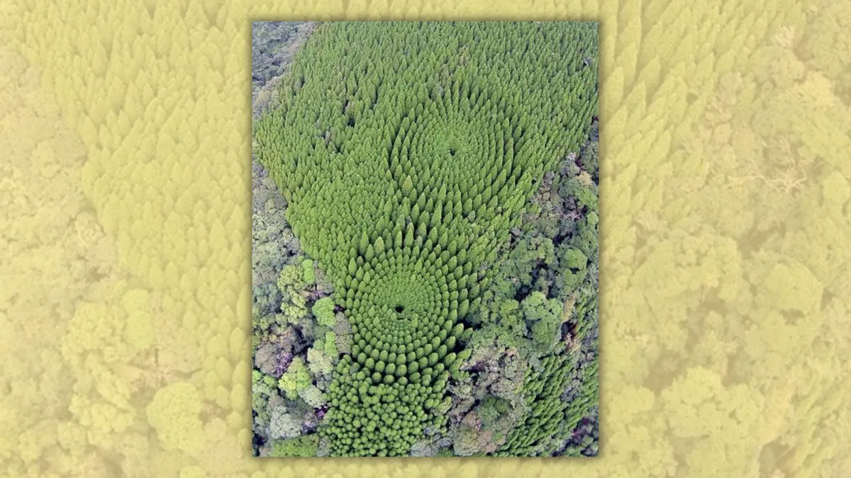
A viral photograph genuinely depicts a unique “experimental forestry” initiative in Japan.

Though the image gained renewed traction online in late 2026, it originally surfaced publicly in December 2018.
Social media feeds lit up with an aerial view of trees arranged in striking concentric circles, prompting widespread discussion about what users described as a decades-old Japanese forestry trial.
“Back in 1973, Japan planted trees in neat concentric circles to study spacing effects in forestry. This is the incredible view from above today,” stated a viral Reddit post (archived).

(Reddit u/Impressive_East_)
This striking visual and similar angles of the same location have consistently popped up across the internet over the years, making appearances on platforms like Instagram, 9GAG, Facebook, Pinterest, and X.
Ultimately, both the photograph and the narrative behind it are entirely accurate. The image captures two distinct experimental plots of Japanese cedar situated close to Nichinan, located within the Miyazaki Prefecture on Kyushu island. Official records from the Miyazaki Southern Forest Management Office confirm that the project was initiated during the 1973 fiscal year to analyze how varying planting densities influence overall tree development and timber quality.
While the photograph circulated broadly, it is not a recent capture; its origins trace back to at least late 2018.
The woodland curiosity has previously caught the public eye, including prior investigations into identical imagery. Some of these pictures have even been cataloged in The Associated Press’ visual library.
Where the Image Started
The visual first caught widespread attention when Japanese media outlet Sankei News featured it in a feature story detailing the unique landscape.

(www.sankei.com)
Credit for the photograph was given to the Miyazaki Southern Forest Management Office, a local branch operating under Japan’s Forestry Agency. Its initial caption translated to: “A circular pattern visible in the mountains of Nichinan City, Miyazaki Prefecture.”
Understanding What the Photo Depicts
The circulating photos highlight Japanese cedar trees planted in dual sets of concentric rings inside a state-managed forest near Nichinan. According to an archival AP description, specimens located in the outermost ring reached heights of roughly 20 meters (66 feet), towering about 5 meters (16 feet) higher than those tucked toward the middle.
Curious observers can even pinpoint the geometric forest using Google Maps and Google Earth by entering the coordinates provided by management: 31°43’50.0″N, 131°23’05.0″E.
Agency documentation indicates the initiative was spurred by shifts within the timber sector. While regional Obi cedar was historically spaced out broadly to yield shipbuilding materials, market demands eventually shifted toward general construction timber.
To evaluate optimal growing conditions, foresters set up the trial in 1973, placing the cedar seedlings into the ground by March 1974. Trees were arranged in expanding rings at decreasing intervals, resulting in planting densities ranging from roughly 377 to 10,027 trees per hectare. From an aerial perspective, this geometric layout formed the distinct patterns often referred to online as “mystery circles.”
Decades of subsequent monitoring demonstrated a clear link between spacing and plant maturation. A 2011 analysis suggested that maintaining a density of roughly 2,000 to 2,800 trees per hectare worked well for economical forestry practices. Furthermore, the final evaluation report released for the 2023 fiscal year concluded that lower densities—1,500 trees or fewer per hectare—can prove highly efficient when balancing afforestation expenses against future financial returns.